Tuesday, December 5, 2017
Special Topics in GIS Lab 14
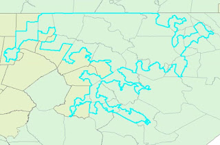
This week in the lab we focused on the topic of Gerrymandering which is the representation of of a population through skewed congressional districts. We looked at metrics that could be used to measure the skewness of the districts. The two metrics used were compactness and community. Compactness measured how spread out and unnatural the district's shape was while community measured how many counties the district overlapped either completely or partially. For compactness the equation 400pi(area)/(perimeter)^2 can be used to get a value. This equation produces a result from 0-100
where 100 is the best compactness (a circle). The lowest compactness or 0 would be the worst case where the perimeter is very large and the area very small. For
community the measurements were derived from running an intersect to see how
many counties were divided into sections by the districts spatially and how many counties were included
in each district total. Then the total divided counties were divided by the
total counties within the districts to display a percentage of counties
divided. Below are some examples of worst compactness and community scores. The first demonstrates low compactness and the second low community.
Labels:
GIS5935
Subscribe to:
Post Comments (Atom)


No comments:
Post a Comment